
- KEY FEATURES
- SPECS
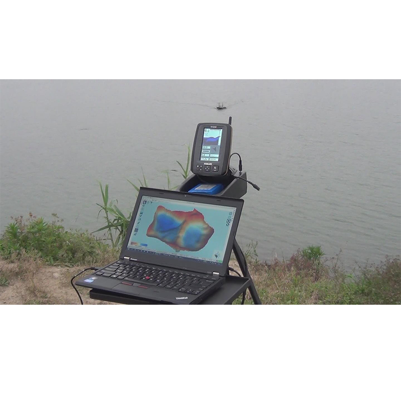
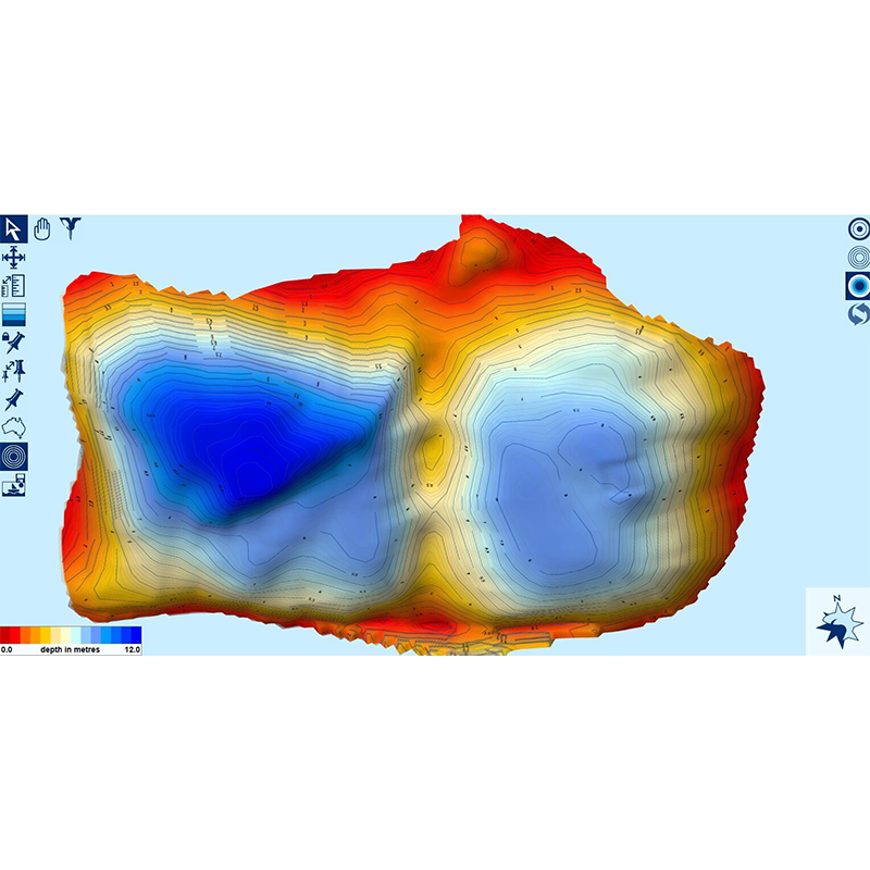
TF650 can create 3D map of water bottom (lake, river, etc ) with Reefmaster mapping software. Are you curious what’s the bottom shape under the water? Simply drive the bait boat (with TF650) across it and you can create a live 3D map of the water area. TOSLON TF650 provides a perfect solution for users to do that by combining the sonar tech and GPS data into hydrographic maps. TF650 (with a bait boat) collects depth data and transmit them to your laptop / PC by a transmitter. Then with the Reefmaster map software you will create the 3D map on your laptop / PC. TOSLON TF650 let anglers precisely know the water bottom shape, which will help them easily find new fishing spots. And it also can be used by industrial or commercial customers, like hydrologic exploration company, dredging companies, etc.
KEY FEATURES
GPS and Compass
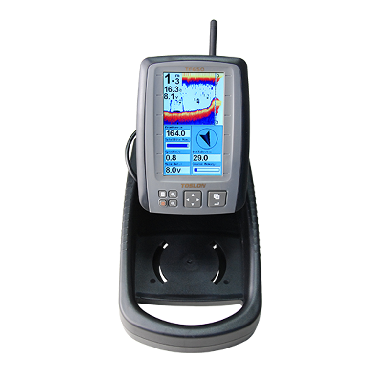
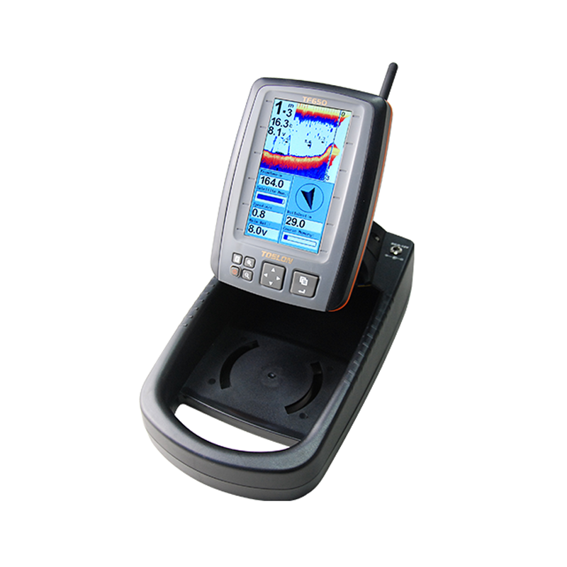
GPS data display Distance to target, Distance to Home,Speed of boat,Time to Board,Satellite Number,Heading,Bear, Course Memory,Time of day,Main Battery.
Compass indicatior of the instant boat heading direction on screen (a red "+" on screen indicate the target)
Indicator of the position and distance to target waypoint and HOME
Boat arriving alarm
Singal lost alarming
Indication of satallite condition by color bar: red(0~3satallites); Yellow(3~6); Blue(>6)
Show the current position as latitude/longitude in decimal degrees
20 RF channels allow different users operationg at same region without interference
Detailed waypoint information including icon, name, date, etc,
Zoom in/Out route display
Sonar
Adopt brand new digital wireless sonar system
Real time sonar windows display the latest sonar returns
Color Line separates fish and structure from the bottom, and defines bottom hardness.
Display target depth reading above each fish symbol as a guide for quick and precise lure presentations.
Sonar alarm: fish / shallow / low battery(boat battery and display battery)
3 background colors
Built-in temp sensor in transducer
Others
Windows style of menu system.
Full one-year warranty; extended warranties available
SPECS
| Specifications | ||
| GPS and RF | GPS Position Accurancy | CEP(circular error probability): 2.5m |
| Field test position accuracy: 1m | ||
| Waypoint storage | 500 | |
| Route | 10 | |
| Radio frequqncy | 2.4GhHz | |
| RF Range | 300m(1000ft) | |
| RF channels | 20 | |
| Speed of boat | yes | |
| Longitude and latitude | yes | |
| Satallite | 50 Channel | |
| Update rate: 1 second | ||
| Hot start<1 second(open sky) | ||
| Cold start<48 second(open sky) | ||
| Sonar | Sonar frequency | 455kHz |
| Depth capability | 80ft | |
| Sonar coverage | 35degree | |
| Compass | Compass built in GPS receiver | yes |
| Compass built in display | yes | |
| compass calibration function | yes | |
| Communication | Data Port | NEMA 0183 Data Port |
| Baud Rate: | 4800/9600/38400/115200Bps, (Default: 115200Bps) | |
| Sentence: | SDDBT / GPRMC / GPGGA | |
| Upadate Rate: | 1Hz | |
| PC Software: | Reefmaster Professonal | |
| Power | Power supply of display | 6~12v lithium battery or 8*AA battery |
| Power supply of controling box | Powered by bait boat battery | |
| DC 6~12v / 2.0w (lithium battery or 8*AA battery) | ||
| Display | Display Size | 4.3"TFT LCD; Sunlight Viewable |
| Resolution | 480*272Pixels; 65,536 color | |
| Multi-language | Yes | |
|
Technical
and casing
|
Sonar unit size | 153 x110 x 44mm |
| Portable case size | 262 x 150 x 98mm | |
| GPS receiver cable length | 1.0m | |
| Transducer cable length | 0.5m | |
| Operational temperature |
-10°C ~ 50°C |
|